Stories · News
Why the Philippines has 24 active volcanoes, seen through Budots Media's 3D models
A 3D map of 24,082 earthquakes shows the plates sinking beneath the islands, while a terrain model puts Kanlaon, still at Alert Level 2, in focus.
Add balita.fyi as a preferred source on Google
The Philippines has 24 active volcanoes, according to the Philippine Institute of Volcanology and Seismology (PHIVOLCS). Its list, of volcanoes that erupted within the last 600 years or, based on young deposits, the last 10,000 years, runs from Iraya on Batan Island in Batanes, in the far north, to Bud Dajo in Sulu, in the far south.
Key figures
Plates that dive beneath the islands
PHIVOLCS explains why there are so many. The country sits on "a unique tectonic setting ideal to volcanism and earthquake activity," at the boundaries of the Philippine Sea Plate and the Eurasian Plate, both of which subduct, or dive, beneath the archipelago along deep trenches off its eastern and western seaboards.
Earthquakes reveal those sinking plates. Budots Media's 3D earthquake model, built in September 2026, places every magnitude 4 or larger earthquake recorded in and around the Philippines since 1970, 24,082 events from the US Geological Survey's ComCat catalogue, at its hypocentre, the underground point where it started. Alongside them it draws Slab2, a scientific model of four subducting slabs: the Manila Trench, Philippine Trench, Cotabato Trench and Halmahera slabs. Budots Media describes the earthquakes as tracing those slab surfaces.
A count of the catalogue behind the model shows how deep the shaking goes: 17,492 earthquakes, or 72.6%, began less than 70 km down. But 6,590, or 27.4%, began deeper than 70 km, and 735 deeper than 300 km. The deepest, a magnitude 5.1 earthquake on 31 March 2000 that USGS located 22 km east-southeast of San Pablo, began 678 km below the surface.
All 578 earthquakes deeper than 500 km lie south of latitude 10.1 degrees north, and 573 of them fall within the area covered by the Halmahera slab model.
Slab2 also shows how deep the plates lie beneath volcanoes. At the grid point nearest each summit, the top of the Philippine Trench slab sits about 111 km beneath Mayon and about 106 km beneath Bulusan, and the Manila Trench slab about 92 km beneath Pinatubo. Of the 13 active volcanoes above the Manila or Philippine Trench slab models, 10 sit where the slab top is between 88 and 124 km deep.
The model notes its limits: about 40% of hypocentres sit at fixed standard depths of 10, 33 or 35 km, and magnitude scales are mixed. Readers can explore the 3D earthquake model.
Source: USGS ComCat via Budots Media 3D model
Table
| 0–35 km | 10,657 earthquakes |
|---|---|
| 35–70 km | 6,835 earthquakes |
| 70–150 km | 4,746 earthquakes |
| 150–300 km | 1,109 earthquakes |
| 300–500 km | 157 earthquakes |
| 500 km and deeper | 578 earthquakes |
Kanlaon in three dimensions
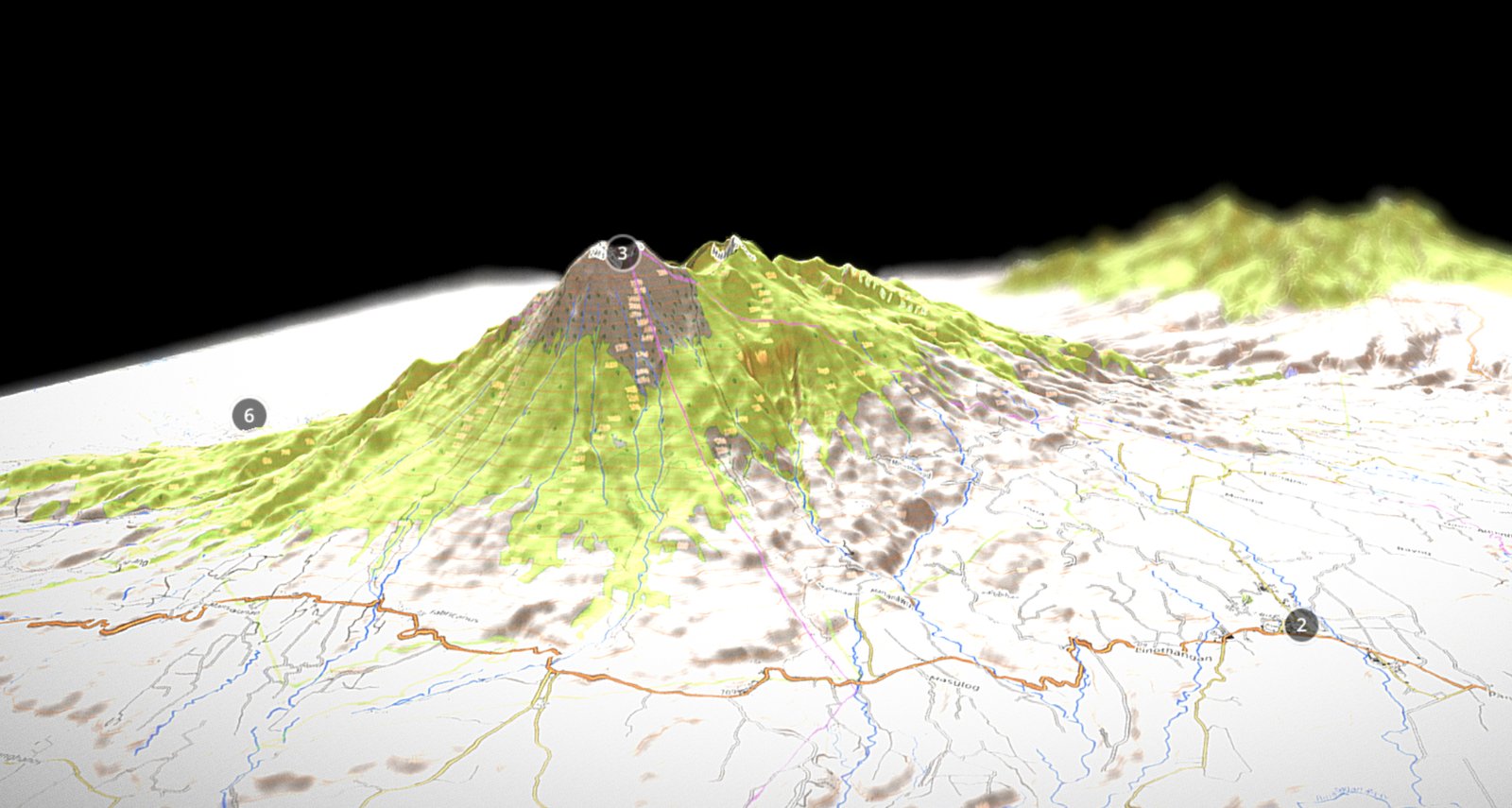
Kanlaon straddles Negros Occidental and Negros Oriental. Budots Media built a 3D terrain model of the volcano in December 2024 from NASADEM elevation data, with an OpenTopoMap map of roads, rivers and towns draped over its slopes. The mesh has about 762,000 points, and its render is dated 10 December 2024, the day after a major eruption.
PHIVOLCS's eruption record groups Kanlaon's activity from 3 June 2024 to 24 August 2026 as one episode. It began with an explosive eruption that sent an incandescent plume 5,000 m above the crater. On 9 December 2024 at 3:03 p.m., an explosive eruption lasting three minutes and 55 seconds sent a plume 4,000 m above the vent, PHIVOLCS said in an update the next morning. Pyroclastic density currents, hazardous mixtures of hot gas, ash and rock, travelled an estimated 2 to 3.4 km down the south-southeastern slopes. Ash fell over a wide area west of the volcano, as far as Iloilo, Antique and Guimaras.
PHIVOLCS raised Alert Level 3 and recommended evacuating communities within 6 km of the summit crater. The Associated Press, citing the Office of Civil Defense, reported that about 87,000 people were being evacuated.
The PHIVOLCS record lists further explosive eruptions on 6 February, 8 April, 13 May and 24 October 2025, and on 19 and 26 February, 15 March and 9 July 2026. PHIVOLCS lowered Kanlaon to Alert Level 2 on 29 July 2025, citing a general decline in the readings it monitors, ABS-CBN News reported. The 9 July 2026 eruption lasted three minutes and sent a dark grey plume two to three kilometres above the crater, SunStar reported, citing PHIVOLCS.
Seen from below in the earthquake model, Kanlaon sits above none of the four slabs, and the catalogue lists only 33 earthquakes of magnitude 4 or more within 50 km of the summit since 1970, the largest a magnitude 6.7 on 6 February 2012 near Jimalalud, about 46 km away. The volcano's own earthquakes, tracked by PHIVOLCS's Kanlaon Volcano Network, mostly do not appear in the M4+ catalogue: PHIVOLCS counted 47 in one day, while the catalogue lists one event within 50 km since June 2024.
What residents should know
PHIVOLCS's alert scheme for Kanlaon runs from 0 to 5. At Alert Level 2, magma is probably intruding at depth, which may or may not lead to a magmatic eruption, and entry into the four-kilometre Permanent Danger Zone (PDZ) must be prohibited. At Level 3, danger zones may be expanded to 6 km; at Level 4, to 10 km or more; at Level 5, to 14 km.
The 5 October 2026 bulletin kept Kanlaon at Alert Level 2. It recorded 47 volcanic earthquakes in 24 hours, sulfur dioxide emissions of 2,203 tonnes a day on 4 October, a 600-metre plume, and inflation of the volcano with short-term deflation. PHIVOLCS said entry into the PDZ and flying close to the volcano should not be allowed, and warned of possible sudden steam-driven eruptions and precursory magmatic activity.
The same day, PHIVOLCS's status board showed Mayon in Albay, where an effusive eruption began on 6 January 2026, also at Alert Level 2; Taal in Batangas and Bulusan in Sorsogon at Alert Level 1; and Pinatubo at Alert Level 0.
PHIVOLCS ranks pyroclastic density currents as the deadliest volcanic hazard, and warns that lahars in the tropics mainly come from heavy rain on loose deposits of past eruptions. It publishes daily bulletins in English and Filipino, and its preparedness materials include a Cebuano guide to Kanlaon's warning signs.
Timeline
Kanlaon explosive eruption sends an incandescent plume 5,000 m above the crater. PHIVOLCS eruption record
Explosive eruption with a 4,000 m plume; Alert Level 3 raised and 6-km evacuation recommended. PHIVOLCS
Another explosive eruption at Kanlaon. PHIVOLCS eruption record
PHIVOLCS lowers Kanlaon to Alert Level 2. ABS-CBN News
Three-minute explosive eruption with a plume 2 to 3 km high. SunStar, citing PHIVOLCS
Kanlaon stays at Alert Level 2 with 47 volcanic earthquakes in 24 hours. PHIVOLCS
Sources
Written and translated by AI (Claude) using only the reports listed below. Read the full story at the original source.
- Associated Press (via KTVZ) — Mass evacuation of Philippine villages underway after a brief but major volcanic eruption
- Budots Media — Kanlaon volcano 3D terrain model (NASADEM DEM mesh with OpenTopoMap, December 2024)
- PHIVOLCS — KANLAON VOLCANO ERUPTION UPDATE 10 December 2024 03:30 AM
- ABS-CBN News — Phivolcs lowers alert status of Kanlaon Volcano to level 2
- SunStar — Kanlaon Volcano erupts, sends ash plume up
- Budots Media — Philippine Earthquakes 1970–2026 in 3D
- USGS — ComCat query used for the Budots Media model (M4+, 115.5–128.5°E, 4–21.5°N, 1970-01-01 to 2026-09-29)
- PHIVOLCS — Volcano bulletins and alert level status (PHIVOLCS-LAVA)
- PHIVOLCS — Kanlaon Volcano Summary of 24Hr Observation, 05 October 2026
- PHIVOLCS — Volcanoes of the Philippines | PHIVOLCS
- PHIVOLCS — Introduction to Volcanoes | PHIVOLCS
- USGS — ANSS Comprehensive Earthquake Catalog (ComCat)
- Slab2 (Hayes et al. 2018, Science 362:58–61), via Budots Media 3D model — Slab2 subducting-slab depth grids: Manila, Philippine, Cotabato and Halmahera slabs
- OpenTopoMap / OpenStreetMap contributors — Map style © OpenTopoMap (CC-BY-SA); map data © OpenStreetMap contributors, SRTM (texture of the Kanlaon 3D model)
- PHIVOLCS — Volcano Alert Levels | PHIVOLCS
- PHIVOLCS — Volcano Preparedness | PHIVOLCS
- PHIVOLCS — Eruption History (Ongoing Audit): Kanlaon
- PHIVOLCS — Eruption History (Ongoing Audit): Mayon
 Pageant season: Filipinas chase Miss Grand, Miss Universe and Miss International crowns
 DOE admits planning failure behind Visayas power shortage
 Typhoon Choi-Wan's trough brings scattered rains to Mindanao, parts of Visayas